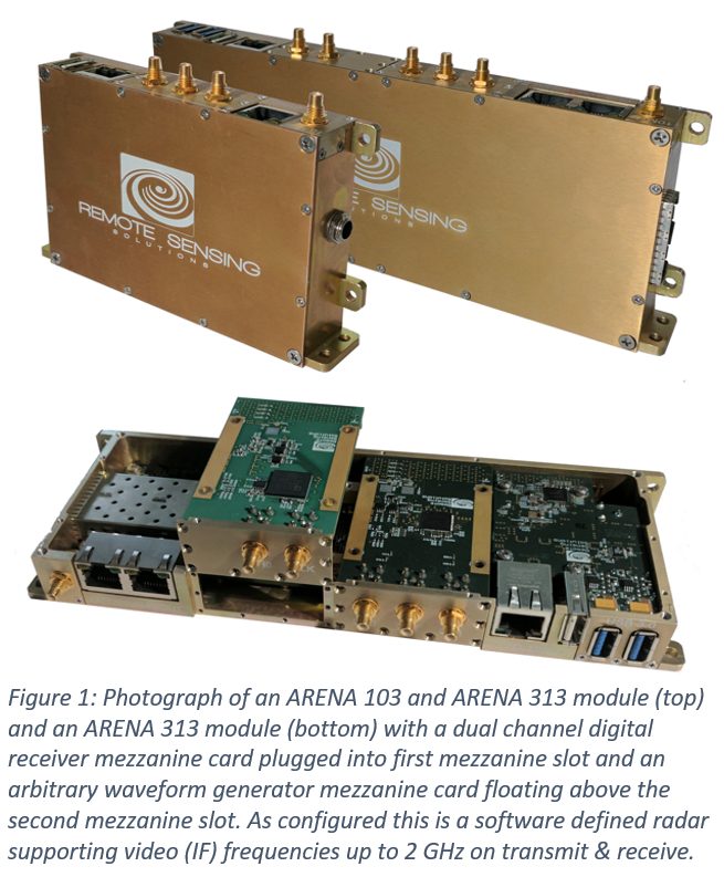
Company News
-
RSS Delivers GLISTIN-A to NASA JPL
RSS recently delivered the first high power, dual-channel, solid-state Ka-band radar system for the NASA airborne Glacier and Ice Surface Topography Interferometer (GLISTIN-A), developed for swath-mapping of ice-surface topography. Now at NASA’s Jet Propulsion Laboratory, the system is undergoing full integration and testing in preparation for engineering test flights this summer on a NASA Gulfstream III . This system achieves sensitivity comparable to tube-based system while occupying a fraction of the volume and achieving unparalleled phase and amplitude stability.
-
Dr. James Carswell receives NASA Group Achievement Award for his contributions to the GRIP Mission
Dr. James Carswell is a recent recipient of the NASA Group Achievement Award for outstanding achievements during the Genesis and Rapid Intensification Processes (GRIP) Mission. The GRIP experiment was a NASA airborne Earth science field experiment in 2010 that was conducted to better understand how tropical storms form and develop into major hurricanes. RSS' HIWRAP system was deployed on a NASA Global Hawk UAV as part of this experiment. The Group Achievement Award is one of the most prestigious awards a group can receive and is presented to groups who have distinguished themselves by making oustanding contributions to the NASA mission.
-
Telephonics Corporation partners with Remote Sensing Solutions to Develop Advanced Millimeter-Wave Radar Imaging and Processing Systems
On December 12, 2011, Telephonics Corporation, a wholly-owned subsidiary of Griffon Corporation (NYSE: GFF) and Remote Sensing Solutions (RSS), announced today that they have teamed to develop and produce advanced millimeter-wave radar imaging and processing systems to address a wide-range of commercial and military applications. This collaboration merges the advanced product development and manufacturing skills of Telephonics with RSS’ outstanding ability to innovate and advance microwave and millimeter-wave imaging radar and processing systems.
“We are very pleased to be working with RSS on important capabilities with near-term applications in the Civil and Military markets,” said Kevin McSweeney, President of Telephonics’ Radar Systems Division. “The Telephonics/RSS team is an excellent paring of expertise, focus, and experience that will add great value to the marketplace.”
-
RSS Welcomes Dr. Yi Chao as Principal Scientist in Atmospheric and Oceanic Sciences
Dr. Yi Chao has joined Remote Sensing Solutions (RSS) as a Principal Scientist. Dr. Chao brings to RSS more than 20 years of experience managing R&D projects in ocean modeling and data assimilation. In addition to his research experience, Dr. Chao played a key role as the Aquarius Project Scientist in the development and implementation of NASA's first ocean salinity satellite. Dr. Chao also held management positions at JPL as Group Supervisor and Section Manager. He is currently an Adjunct Professor in the Joint Institute for Regional Earth System Science and Engineering (JIFRESSE) at UCLA.
“We are very excited to have Yi join our team,” said Dr. Carswell, President of RSS. “As a Principal Scientist here, he will continue his leadership role in ocean modeling and data assimilation. RSS has established itself as a developer and provider of state-of-the-art remote sensing technologies, and with Yi joining our team, RSS will be able to extend its capabilities to forecasting and prediction.” Dr. Chao said, “I am thrilled to incorporate modeling and forecasting technologies with RSS' remote sensing capabilities to provide comprehensive solutions for the communities we serve.” Click here to read Dr. Yi Chao's biographical sketch.
-
Remote Sensing Solutions develops apps for Real-Time Transmission of NOAA Tail Doppler Radar Data
In 2010, NOAA NESDIS, NOAA AOC, NOAA HRD and Remote Sensing Solutions teamed to capture Doppler measurements from volume backscatter precipitation profiles and send the radial Doppler profile observations to National Weather Service in near real-time over satellite communication data link. The end objective is to provide these Doppler profiles, and other atmospheric and oceanic observations, in a routine and automated fashion to NWS and others in the forecasting community for operational utilization in support of hurricane forecasting and warning. Click here to read more.
Welcome
Remote Sensing Solutions (RSS) develops integrated systems and innovative software applications used by the scientific community, operational agencies of the government and the private sector.
RSS is an agile systems provider centered on research and development within the realm of remote sensing technologies. Our focus ranges from the development and application of microwave and millimeter-wave systems providing terrestrial, surface water, ocean and atmospheric remote sensing and imaging to the design and deployment of web-based real-time data processing and visualization applications.
Remote Sensing Solutions' mission is to develop innovations in remote sensing techniques, hardware, digital processing and data management and visualization for the government, science communities and private sector. RSS' engineering team has extensive experience in hardware and software systems development for the remote sensing, cellular and telecommunications industries. This expert team enables RSS to develop innovative and highly reliable, complex systems with advanced network management capabilities. RSS engineers have accumulated over eighty years of experience in these fields.
Technology and Instrument Showcase
GLISTIN-A
Remote Sensing Solutions (RSS) and the Jet Propulsion Laboratory (JPL) teamed to design and build the Airborne Glacier and Land Ice Surface Topography Interferometer (GLISTIN-A). Planned for deployment this summer as part of the UAVSAR configuration on the NASA Gulfstream III aircraft, this new system will provide single pass ice surface topography mapping over 10 km swath with 10 cm to 50 cm resolution.
The original system (GLISTIN) was developed through the NASA International Polar Year program in which RSS and JPL first demonstrated the capability of airborne Ka-band interferometry to provide wide-swath topography. GLISTIN-A's unique use of solid-state technology and ping pong geometry produces a very compact sensor that is deployed directly on the UAV SAR panel, external to the aircraft fuselage, and will be compatible with deployment on the NASA Global Hawk UAV and other high altitude platforms.
* Image produced by Scott Hensley, JPL from original Ka-band interferometric measurements.
The RSS Internet-based Radar Digital Receiver and Processor (iRAP) system is a high fidelity, modular processing system for radar applications. Easily reconfigurable at both hardware and firmware levels, it provides a cost effective solution that can be optimized for each application.
With its Linux-based network processor, it provides multiple independent gigabit Ethernet interfaces to other systems and client applications. Its FPGA-based processing cards can implement a variety of tasks including, multi-channel digital receivers, waveform generation, Doppler / spectral processors and synthetic aperture processing. With interchangeable mezzanine cards, each FPGA processor module can be configured with different external interfaces.
iRAP's unique mesh system architecture provides ultra high-speed data communication between its processing cards allow for complex parallel processing. Through a switch fabric PCIe module and embedded DMA engines on the FPGA cards, data and products can be passed through the network processor to client applications, network storage, and downstream processing applications at rates exceeding 120 MB/s per network interface.
Its conduction cooled design is very compact and can operate at altitudes up to 70 kft. The system has been deployed on the NASA Global Hawk UAV and NASA ER-2 aircraft. iRAP was developed wiht funding from the NOAA SBIR program and the NASA IIP.
HIWRAP
Remote Sensing Solutions (RSS), NASA Goddard Space Flight Center (GFSC) and the University of Massachusetts (Umass) teamed through the NASA Instrument Incubator Program to develop the High Altitude Imaging Wind and Rain Airborne Profiler (HIWRAP) for deployment on the NASA Global Hawk and other high altitude aircraft. The HIWRAP is a solid-state conical scanning, dual-frequency, dual-beam Doppler radar. It acquires volume and surface backscatter profiles simultaneously at Ku and Ka-band wavelengths and two incidence angles (30 an 40 degrees).
From these measurements it maps
the 3-dimensional tropospheric and atmospheric winds, ocean vector
surface winds and precipitation field in and around tropical cyclones
and severe ocean storms.
To achieve high sensitivity and overcome range-Doppler
ambiguities, HIWRAP uses a novel transmit waveform (frequency diversity pulse
compression) developed through a RSS NASA STTR project. HIWRAP has been
deployed on the Global Hawk in the NASA Genesis and Rapid
Intensification Processes (GRIP) experiment and on the NASA ER-2
in support of Global Precipitation Measurement (GPM) Mid-Latitude
Continental Clouds Experiment (MC3E). HIWRAP is to participate on
the Global Hawk in the multi-year hurricane study (HS3).
D3R
Leveraging a novel transceiver and waveform design developed during a RSS NASA Phase II project, Remote Sensing Solutions, Colorado State University and NASA Goddard Space Flight Center teamed to develop the Dual-wavelength, Dual-polarized Doppler Precipitation Radar (D3R). This innovative solid-state radar systems is serving as a calibration/validation radar system for the Global Precipitation Measurement (GPM) mission.
It acquires dual-polarized Doppler and reflectivity precipitation volume backscatter measurements simultaneously at Ku and Ka-band wavelengths. Utilizing frequency diversity pulse compression approach, it achieves sensitivity close to traditional tube-based precipitation radars while suffering no blind region. Internal calibrations enable the system to maintain better than 0.1 dB stability.
* Photo courtesy of NASA Goddard Space Flight Center.


